See Differently, Think Differently
EarthPaper analyzes, interprets, and extracts insights from satellite imagery. We turn complex data into clear insights anyone can understand.
Discover
Global Issues Uncovered Through Satellite Imagery
Looking for satellite imagery?
From satellite imagery purchase to super resolution, tailored solutions for your needs
Analyze
Smart Analytics Solution That Reveals Hidden Insights


Super Resolution
Faster processing, sharper imagery!
Our super resolution technology enhances the spatial resolution of satellite images, up to 3× clearer — without distorting the original data. This advanced SR technology is already recognized as a leading solution in the global market.


Gap Filling
Ensuring data accuracy and reliability!
This technology restores missing data caused by clouds or obstructions while maintaining data integrity. Our advanced solution supports rapid recovery, up to 50 times faster in AWS EC2 environments, delivering results within 24 hours.


Image Fusion
Achieve temporal resolution, spatial resolution, and gap-filling — all at once!
The deep learning algorithm accurately detects areas covered by clouds and shadows. Image fusion, which clearly restores missing regions, can be applied to various satellites such as Sentinel-2 and Landsat-8, and provides imagery with higher temporal and spatial resolution.
Apply
Find the Truth in Your Data, Smart Analytics Package
Natural Disaster Management
We use satellite imagery and deep learning to rapidly and accurately analyze disaster damage, predict ground risks and impact scale, and support the development of recovery and mitigation systems. By leveraging accumulated data, we also identify disaster risks in advance and strengthen proactive response systems.
Analysis Solution Overview.pdfIdeal for organizations that:
- Measure disaster impact
- Assess insurance losses
- Prioritize emergency aid


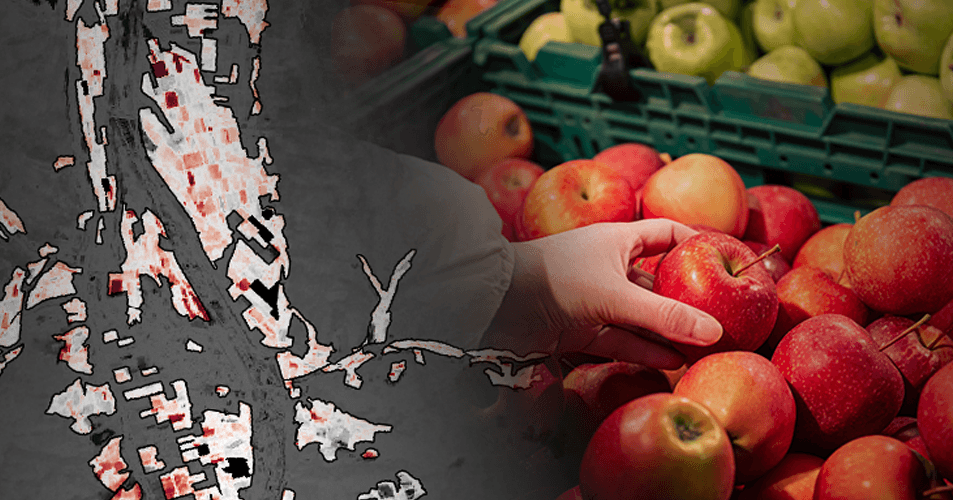
Agriculture
We analyze satellite imagery to assess crop health and forecast future yields. By predicting the productivity of major crops such as corn, soybeans, and wheat, and providing detailed analysis through crop type classification, we help optimize cultivation strategies backed by scientific data — improving both efficiency and resilience in agriculture.
Analysis Solution Overview.pdfIdeal for organizations that:
- Monitor crop health
- Forecast yields & prices
- Assess agri-investment risks


Environment Monitoring
We use satellite imagery to track environmental change and support climate action and resource management. Our capabilities include monitoring carbon sinks through land cover, forest, and vegetation analysis; managing water resources by observing dam levels and coastline shifts; and supporting renewable energy planning by detecting sea ice, drought conditions, and solar panel distribution.
Analysis Solution Overview.pdfIdeal for organizations that:
- Pursue climate & carbon neutrality
- Analyze ecosystems for research
- Drive ESG & carbon investments


Defense & Security
We analyze both optical and SAR satellite imagery to detect changes in areas of interest quickly, regardless of weather or time of day. This allows for rapid identification of military and infrastructure developments, precise tracking of land, sea, and air movements, and early detection of potential threats. In addition, we deliver quantitative damage assessments in conflict and disaster zones to support fast decision-making and effective mission planning.
Analysis Solution Overview.pdfIdeal for organizations that:
- Track conflicts & threats
- Leverage geospatial intelligence


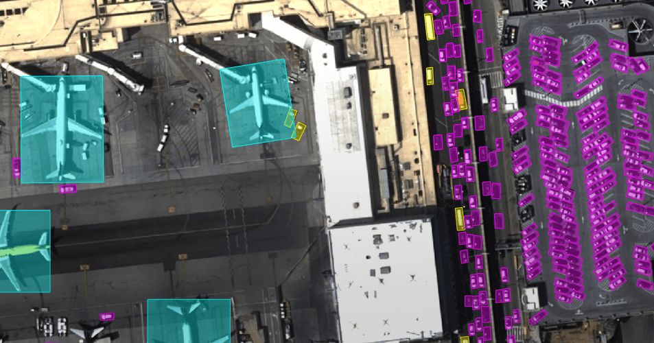
Urban / Infrastructure Management
Using satellite imagery and deep learning, we automatically detect key urban features — including buildings, roads, vehicles, ships, and aircraft — to deliver timely insights into city conditions. We also produce land cover maps that clearly illustrate land use, enabling effective monitoring and analysis of urban change.
Analysis Solution Overview.pdfIdeal for organizations that:
- Manage urban renewal & infrastructure
- Monitor land use & construction
- Develop smart city strategies


Finance & Insurance
We use satellite imagery to identify global economic trends and commodity market shifts ahead of official reports — reducing investment risks and uncovering new opportunities for investors and policy-makers alike. Leveraging deep learning, we precisely monitor port activity, cargo volumes, and oil storage levels. We also assess factory operations and broader economic activity using surface temperature data and nighttime light analysis.
Analysis Solution Overview.pdfIdeal for organizations that:
- Track markets & commodities
- Analyze supply chains


Looking to analyze satellite imagery?
We uncover hidden details to deliver insights tailored to your business